Location: Meade Country, South Dakota
Bear Butte State Park, situated in western South Dakota
approximately six miles northeast of the town of Sturgis off SD
Highway 79, showcases a remarkable geological feature as one of
several igneous rock intrusions in the Black Hills region. This
laccolith formed during the Eocene Epoch around 56 to 34 million
years ago, when magma intruded into cooler crustal rock, uplifting
sedimentary layers that have since eroded away, leaving the butte
standing prominently. The peak rises 1,253 feet above the
surrounding plains, reaching an elevation of 4,426 feet above sea
level, and serves as a vital landmark in the landscape. Revered as a
sacred site by numerous Native American tribes, including the Lakota
and Cheyenne, the mountain attracts pilgrims who engage in religious
ceremonies, prayers, meditation, and offerings such as colorful
prayer cloths and tobacco bundles tied to trees along its flanks.
Visitors are encouraged to respect these practices by leaving
offerings undisturbed and avoiding photography of them.
In
Lakota, the site is called Mato Paha, translating to "Bear
Mountain," reflecting its bear-like shape or spiritual associations.
The Cheyenne refer to it as Noahvose or Náhkȯhe-vose, meaning "Bear
Hill" or "Giving Hill," where their prophet Sweet Medicine received
sacred instructions from Ma'heo'o (the Great Spirit), forming the
foundation of Cheyenne religious, political, social, and economic
customs.
Exact Location and Access Basics
Physical address: 20250 SD
Highway 79 (or 1 Bear Butte State Park Dr.), Sturgis, SD 57785.
GPS
coordinates: Latitude 44.45989°N, Longitude -103.4509°W.
Nearest
major town: Sturgis (population ~7,000), which has groceries, fuel,
lodging, and services.
Park entrance: A short gravel road off the
west side of SD Hwy 79 (northbound traffic turns left; southbound turns
right). The prominent butte is visible for miles and serves as a natural
landmark.
Park entrance license required: $10/day for SD residents or
$15/day for non-residents per vehicle (annual passes available). Pay at
the self-serve kiosk or visitor center.
The park is rural with no
public transit directly serving it. A personal vehicle, rental car,
taxi/rideshare, or shuttle is essentially required. Roads are paved
state highways that are well-maintained but can have snow/ice in winter
or heavy traffic during events.
Getting There by Car (Recommended
and Most Common)
Bear Butte is straightforward to reach via the
interstate and state highways. Total driving is short once you’re in the
Sturgis area.
From Sturgis, SD (Local Access – ~15 minutes, 6 miles)
Start in downtown Sturgis and head east on Lazelle Street, which
becomes SD Highway 34 (also signed as 206th Street).
Continue east on
Hwy 34 for approximately 3–3.5 miles, passing Fort Meade, Sturgis Brown
High School, and the Kick Start Travel Center.
At the intersection
with SD Highway 79, turn north (left) onto Hwy 79 (also called 131st
Avenue).
Drive north on Hwy 79 for about 1.7–2.5 miles. The park
entrance will be on your left (west) side. Look for park signs and the
butte ahead. (If you reach Bear Butte Lake, you’ve gone about a mile too
far.)
The route is flat-to-rolling prairie with clear signage. No
major hills or difficult turns.
From Rapid City, SD, and Rapid City
Regional Airport (RAP) (~33 miles, 35–45 minutes)
Take I-90 East
toward Sturgis (the main east-west interstate through the region).
Use Sturgis exits (typically Exit 30, 32, or 34 depending on your exact
starting point in Rapid City).
Follow signs toward Sturgis and
connect to the local route above (Lazelle St / Hwy 34 east, then Hwy 79
north).
Alternative mention in some guides: Exit I-90 and head north
on Hwy 79 directly through/around Sturgis.
This is the most
common approach for visitors to the Black Hills.
From Other Major
Directions
From the east (e.g., Sioux Falls, SD – ~330 miles): I-90
West all the way to Sturgis, then the local route above.
From the
west/northwest (e.g., Billings, MT, or Wyoming): I-90 East into South
Dakota to Sturgis.
From the south (e.g., Denver, CO): I-25 North to
I-90 East (via Cheyenne, WY), or scenic routes through the Black Hills.
Long-distance from Chicago, IL (user’s general area – ~940 miles):
Primarily I-90 West through Illinois, Minnesota, and South Dakota (13–15
hours of pure driving time under ideal conditions, plus stops). Many
break it into 2 days. Flying is far more practical (see below).
Navigation tips: Use Google Maps, Apple Maps, or Waze with the exact
address or “Bear Butte State Park Visitor Center.” Cell service is
generally good along highways but can be spotty in the park itself.
Download offline maps if needed. Roads are two-lane state highways with
good shoulders; watch for wildlife (deer, pronghorn) especially at
dawn/dusk.
Seasonal considerations: Open year-round, but winter can
bring snow/ice on Hwy 79 (4WD or chains recommended in storms). Flush
toilets/water may be off October–April; vault toilets remain open.
Contact the park at (605) 347-5240 for current conditions.
Major
event impact: The Sturgis Motorcycle Rally (early August) brings
500,000+ bikers. Traffic on I-90 and Hwy 79 is extremely heavy, parking
fills fast, and lodging/prices skyrocket. Visit outside this window for
a quieter experience.
By Air + Ground Transport
Nearest major
airport: Rapid City Regional Airport (RAP) – the primary gateway to the
Black Hills (~33–40 miles / 40–60 minute drive to the park).
Nonstop flights from many U.S. cities (Delta, United, American,
Allegiant, etc.).
On-site rental cars (major companies available).
Taxis, rideshares (Uber/Lyft limited but available), and authorized
shuttles outside the terminal.
No direct shuttle to Bear Butte, but
you can arrange private transfers or use a rental.
Smaller local
airports (Sturgis Municipal – 4 miles east of Sturgis) have no
commercial service; they’re for private/general aviation only.
Other
airports (much farther): Sioux Falls (FSD, ~350 miles) or Billings (BIL,
~300+ miles) are alternatives but add significant drive time.
Public Transportation and Other Options
Public transit is extremely
limited in this rural area:
Greyhound serves Rapid City or nearby
stops, but you’ll still need a car/taxi from there.
No regular bus or
shuttle runs directly to the park or even Sturgis outside of the
motorcycle rally period (when temporary “Da Bus” shuttles operate in
town).
Rideshares/taxis from Rapid City or Sturgis are possible but
expensive for one-way trips (~$50–100+ from RAP).
Best option for
non-drivers: Rent a car at RAP or arrange a private shuttle/tour from
Rapid City.
Practical Tips for Arrival
Parking: Ample at the
visitor center, trailheads, and campground (first-come, first-served).
RV-friendly but check site lengths.
Fuel and supplies: Fill up in
Sturgis or Rapid City—limited options near the park.
Respect and
rules: This is a sacred site. Stay on trails, do not disturb offerings,
and be quiet near prayer areas. Horseback riding is allowed only west of
Hwy 79 (not on the butte itself).
Best time: Early morning or late
afternoon for fewer crowds and better light/views. Summer is peak;
shoulder seasons (spring/fall) are ideal for hiking.
Weather/road
checks: South Dakota DOT (sd.gov) or 511 app for highway conditions. The
park is in a transition zone between prairie and hills—windy and
exposed.
Entry to Bear Butte State Park requires a valid park entrance
license, which helps fund maintenance and preservation efforts. Daily
passes are priced at $10 for South Dakota residents and $15 for
non-residents, generally applied per vehicle (up to eight occupants).
For frequent visitors, annual passes offer better value at $40 for
residents and $60 for non-residents, granting unlimited access to all
South Dakota state parks for a full year. These can be purchased online
through the state's licensing portal or at self-serve kiosks on-site.
Camping fees are separate, with non-electric sites available for $16 per
night on a first-come, first-served basis, including options for horse
camping.
In recognition of the site's sacred status, participants
actively engaged in religious activities—such as traditional Native
American ceremonies—are exempt from entrance fees. This policy respects
the cultural heritage and ongoing spiritual use of the area, as outlined
in state administrative rules. Visitors are reminded to treat the site
with reverence: do not disturb prayer offerings like colored cloths or
tobacco ties, and prohibitions include alcohol east of Highway 79,
uncased firearms, and scattering human remains.
The park offers a
range of activities to enhance your visit, including hiking trails like
the 1.85-mile Summit Trail (leading to panoramic views) and the 2.5-mile
Lake Trail around Bear Butte Lake for fishing and picnicking. It's open
year-round, though some facilities like flush toilets may be unavailable
in winter. Horseback riding is permitted west of Highway 79, and the
Education Center provides exhibits on the park's geology, history, and
indigenous cultural beliefs.
Getting There and Park Basics
Location: 20250 Hwy 79, Sturgis, SD
57785 (about 15 minutes from Sturgis, ~30-45 minutes from Rapid City).
Entrance Fees: Daily license is $15 per vehicle for non-residents ($10
for SD residents). Annual pass is $60 non-resident ($40 resident).
Purchase online in advance via the South Dakota GFP site for
convenience, or use the self-serve kiosk (often cash/envelope at smaller
parks like this). Display visibly. Religious participants may be
exempt—check ahead.
Contact: 605-347-5240 or BearButte@state.sd.us.
Education Center (visitor center/museum) is open ~8 AM–6 PM
May–September.
Hours: Park is open year-round. Summit Trail is
accessible from ½ hour before sunrise to ½ hour after sunset. Facilities
like flush toilets/showers may close Oct 1–April 30 (vault toilets
usually stay open).
Pro Tip: Buy your pass online if visiting
multiple SD state parks. Sturgis can get extremely busy during the early
August Sturgis Motorcycle Rally—avoid then unless that's your goal.
Hiking Tips (Main Attraction: Summit Trail)
The Summit Trail is a
1.85-mile one-way (≈3.1–3.6 miles round-trip) moderate out-and-back hike
with ~1,000 feet elevation gain to the 4,426-foot summit. Expect 2–4
hours round-trip depending on pace and breaks. It's steep in sections
with switchbacks, loose rock/gravel, narrow paths, and little shade.
Benches are placed along the way for rests and views.
Difficulty:
Moderate but strenuous due to elevation and sun exposure. Suitable for
fit hikers; take it slow if you're not acclimated. Not recommended for
those with severe fear of heights or mobility issues (narrow trail,
drop-offs in places, no railings everywhere).
What to Expect:
Changing scenery (valley to ridgeline), 360° views at the top (Black
Hills, plains, Bear Butte Lake), possible wildlife (bison at base, deer,
snakes). Trail can be windy; storms roll in quickly.
Best Practices:
Start early (before 9 AM) for parking, cooler temps, and better light.
Wear sturdy hiking shoes (loose rocks), sun protection (hat, sunscreen,
long sleeves), layers, and rain gear.
Bring plenty of water (no
sources on trail) and snacks.
Trekking poles can help on descents.
Stay on trail; respect ceremonies (be quiet, give space).
No dogs,
bikes, or horses on the Summit Trail (too narrow). Pets allowed on leash
in horse camp area west of Hwy 79.
Watch for rattlesnakes
(common—stay alert).
Descend carefully on loose sections.
Lake
Trail (2.5 miles) is easier, following the shoreline—great for a relaxed
walk, fishing access, or combining with the Centennial Trail.
Other Activities
Wildlife & Lake: Observe bison from a safe distance
(they are dangerous—do not approach; maintain at least 25+ yards).
Fishing in 215-acre Bear Butte Lake (SD fishing license required).
Boating, kayaking, shore access, fishing pier.
Camping: 15
non-electric sites + 4 horse sites (first-come, first-served,
~$16/night). Popular on weekends; dry camping with water access and
vault toilets. No reservations—arrive early.
Education Center: Learn
about geology, sacred history, and etiquette. Excellent stop before
hiking.
Centennial Trail: Multi-use for longer adventures (hikers,
bikers, horses west of Hwy 79).
Safety and Respect
Cultural
Sensitivity: This is a living sacred site. Do not touch/remove
offerings, photograph ceremonies without permission, leave ashes, or
disturb worshippers. No alcohol east of Hwy 79.
Weather: Black Hills
weather changes fast—check forecasts. Summer: hot/sun-exposed.
Spring/fall: milder, fewer crowds. Winter: possible snow/ice (trails may
be slick).
Wildlife: Bison, snakes, possible bears (though rare
here). Keep distance; store food properly.
Other: No firearms/bows
east of Hwy 79. Pack out all trash. Tell someone your plans. Cell
service may be spotty.
Best Time to Visit
Ideal: Late spring
(May–June) or early fall (September) for mild temps, wildflowers or
foliage, and lighter crowds.
Summer: Great but hot, sunny, and busier
(avoid rally week).
Avoid: Midday summer heat; early August rally.
Winter for experienced hikers only.
Practical Tips
Parking:
Limited at trailhead/Education Center—arrive early.
Nearby: Sturgis
for lodging/food (hotels, campgrounds, restaurants). Combine with Black
Hills attractions like Mount Rushmore (longer drive) or Fort Meade
trails.
Preparation: Download offline maps (AllTrails is popular).
Bring cash for fees if needed. Check park website or call for current
conditions.
Peter Norbeck Outdoor Education Center
The Peter Norbeck Outdoor
Education Center, situated near the State Game Lodge on Highway 16A,
serves as an engaging hub for learning about the park's rich natural
history, wildlife, and conservation initiatives through interactive
exhibits and programs suitable for all ages. It typically operates from
Memorial Day through late September, with hours from 9 AM to 5 PM,
though visitors should confirm exact times as they may vary slightly
based on the season.
Custer State Park offers a wide array of recreational opportunities
amidst its 71,000 acres of stunning Black Hills landscapes, including
pine forests, granite spires, and open prairies teeming with wildlife.
Whether you're seeking adventure or relaxation, here's a breakdown of
popular pursuits:
Biking: Rent a bike or bring your own to pedal
along designated trails and scenic roads, such as the Wildlife Loop Road
or parts of the Centennial Trail, offering a mix of easy flats and
challenging inclines with breathtaking views.
Boating: Launch
non-motorized boats like canoes, kayaks, or paddleboards on lakes such
as Sylvan, Legion, Stockade, or Center—rentals are available at select
lodges. Always wear a personal flotation device, and note restrictions
like electric-only motors on some waters for a peaceful experience.
Fishing: Anglers can target species like rainbow trout, brown trout,
brook trout, northern pike, and bass in the park's streams and lakes. A
valid South Dakota fishing license is required, along with a habitat
stamp for those 18 and older; daily limits apply, such as five trout per
person.
Game/Equipment Checkout: Borrow equipment for various
activities, including snowshoes during winter months (available for free
checkout from January to March) or other gear like binoculars for
wildlife viewing, making it easy to try new experiences without packing
everything.
Horse Riding: Guided horseback trail rides are offered
from Blue Bell Lodge, lasting 1 to 8 hours through picturesque terrain,
but riding is restricted to areas west of Highway 79 to protect
sensitive zones. No personal horses are allowed outside designated horse
camps.
Watching the Buffalo Herd: One of the park's highlights is
observing the iconic bison herd, which numbers around 1,300 to 1,450
animals and roams freely across the grasslands. The best viewing occurs
along the 18-mile Wildlife Loop Road during early morning or evening
hours when the animals are most active—join a guided Buffalo Safari Jeep
Tour for closer, safer encounters, or attend the annual Buffalo Roundup
in late September for a spectacular event where cowboys herd the bison
for health checks and auctions.
Hiking: With over 50 miles of trails
ranging from easy loops to strenuous ascents, hiking allows exploration
of diverse ecosystems, wildflowers, and panoramic vistas—guided hikes
and naturalist programs are available in summer for added education.
Specific Hiking Trails
1.85-Mile Summit Trail: This moderately
strenuous path, open daily from 8 AM to 7 PM, climbs to elevated
viewpoints offering sweeping sights of the Black Hills; it's ideal for
those seeking a shorter but rewarding challenge with potential wildlife
sightings along the way.
2.5-Mile Lake Trail: A scenic loop around
one of the park's picturesque lakes (such as Stockade or Sylvan),
providing opportunities to spot birds, fish, and riparian vegetation;
it's rated easy to moderate with gentle terrain suitable for families.
Northernmost Point of the 111-Mile Centennial Trail: Serving as the
starting point for this extensive trail system, it accommodates hiking,
biking, and horseback riding through varied landscapes including
forests, meadows, and canyons—perfect for multi-day adventures or
shorter segments, with access to backcountry camping options.
The park provides rustic camping experiences across nine campgrounds, emphasizing a connection to nature without modern luxuries like showers in some areas. Standard sites cost around $6 per site with 16 non-electrical options available, while the dedicated Horse Camp offers 4 non-electrical sites at approximately $8 per site—fees are subject to change, so verify current rates via the official reservation system. Amenities include potable water sources and a picnic shelter for group gatherings. For a more primitive option, the French Creek Natural Area allows backpack camping at $8 per person per night with no open fires permitted. Reservations can be made up to a year in advance through campsd.com, and same-day sites are often available at locations like Center Lake. Note that entrance fees are separate, starting at $25 for a 1-7 day vehicle pass.
While the park's wildlife adds to its allure, bison (commonly called buffalo) are powerful, unpredictable wild animals that can charge if they feel threatened—always maintain a minimum distance of 100 yards, avoid approaching or feeding them, and remain in your vehicle during close encounters along roads. If an animal changes its behavior (like pawing the ground or raising its tail), back away slowly without turning your back. Additional tips include staying on marked trails to avoid hazards like poison ivy or uneven terrain, keeping pets leashed (no longer than 10 feet) and out of buildings or swim areas, and following all regulations such as no drones without proper permits or no collecting natural items. These precautions ensure a safe visit for everyone.
Geological Origins
Bear Butte is not a true butte (formed mainly
by erosion of sedimentary layers) but a laccolith—an intrusive igneous
rock formation created when magma pushed upward into cooler crustal rock
during the Eocene Epoch, roughly 50–65 million years ago, without fully
erupting as a volcano. This process was part of the broader uplift that
formed the Black Hills and similar features like Devils Tower in
Wyoming. Over millions of years, overlying sedimentary rock and soil
eroded away, exposing the hardened, cone-shaped igneous core. The butte
rises approximately 1,200–1,253 feet (about 382 meters) above the
surrounding prairie and reaches an elevation of 4,426 feet (1,349
meters) at its summit.
From the summit, visitors can see four states
on clear days, and the park includes a bison herd at its base, hiking
trails (including the 1.85-mile Summit Trail and portions of the
111-mile Centennial Trail, of which Bear Butte is the northern
terminus), and a visitor/education center.
Indigenous History and
Sacred Significance (Prehistoric to 19th Century)
Artifacts found
near Bear Butte date back at least 10,000 years, indicating long-term
human interest in the area. For at least 4,000 years—and continuing
today—it has been a profoundly sacred site to numerous Plains Indigenous
nations, particularly the Lakota (Sioux) and Cheyenne, as well as the
Kiowa, Arapaho, and others.
Lakota name: Matȟó Pahá ("Bear
Mountain" or "Bear Butte"), evoking the profile of a sleeping bear that
serves as a sentinel over the plains. It features in Lakota creation and
emergence stories and is used for vision quests, prayer, fasting, and
ceremonies.
Cheyenne name: Noahȧ-vose ("Giving Hill"), Náhkȯhe-vose
("Bear Hill"), or similar terms. According to Cheyenne oral tradition,
the culture hero and prophet Sweet Medicine (or Erect Horns) entered the
mountain after being banished from his people. Inside, the Great Spirit
(Ma'heo'o) imparted foundational teachings: the Four Sacred Arrows,
moral codes, religious laws, political and social customs, ceremonial
practices (including elements of the Sun Dance), and knowledge that
shapes Cheyenne identity and society. This makes it one of the
Cheyenne's most sacred sites.
Pilgrims from tribes across the
U.S. and Canada continue to visit for spiritual guidance. Prayer
offerings—colorful cloth ties (prayer cloths) and small tobacco
bundles—are tied to trees along the trails and left undisturbed as acts
of reverence. The site hosts sweat lodges, vision quests, and other
ceremonies year-round.
Key historical events underscore its role:
1857 Grand Council: Many bands of Plains Indians gathered here to form
alliances and strategize resistance against encroaching white settlers
in the Black Hills region.
Prominent leaders such as Red Cloud, Crazy
Horse, and Sitting Bull sought spiritual guidance and visions at the
butte.
1874 Custer Expedition: General George Armstrong Custer camped
nearby during his illegal (under the 1868 Fort Laramie Treaty)
reconnaissance of the Black Hills. He reportedly climbed the butte and
was struck by its power. His report confirming gold rumors triggered the
Black Hills Gold Rush, leading to massive settler influx, treaty
violations, and the confinement of Northern Plains tribes to
reservations.
Euro-American Settlement and Private Ownership
(Late 19th–Mid-20th Century)
After the gold rush and the displacement
of tribes, Bear Butte fell into private hands. Ezra Bovee homesteaded
the southern slopes in the late 19th/early 20th century. By World War
II, the Bovee family held legal title. Remarkably, they welcomed and
encouraged Native American religious use of the site. In spring 1945,
for example, the Northern Cheyenne received explicit permission from the
Bovees to conduct a ceremony on the butte to pray for the end of World
War II.
By the mid-1950s, Ezra Bovee and later his family advocated
for federal protection, lobbying to designate Bear Butte as a national
park to preserve its natural and spiritual value. When National Park
Service interest faded, the state of South Dakota stepped in.
Establishment as a State Park and Modern Era (1961–Present)
In 1961,
South Dakota acquired the land and established Bear Butte State Park,
opening it to the public while recognizing its cultural importance. It
was later designated a National Historic Landmark on December 21, 1981
(some sources note earlier National Historic Site considerations around
1965), and it holds status as a National Natural Landmark and National
Recreation Trail due to its heritage.
Tensions arose between public
recreation/development and the site's sacred status. In 1983, Lakota and
Cheyenne (Tsistsistas) representatives, including Lakota ceremonial
chief Frank Fools Crow (who made lifelong pilgrimages here and advocated
for racial harmony), filed a federal lawsuit (Fools Crow v. Gullett and
related cases). They argued that park facilities, trails, and tourism
diminished the spiritual integrity of the site, seeking greater
protections under the American Indian Religious Freedom Act and the
First Amendment. The suit and subsequent appeals were unsuccessful, but
a compromise emerged: certain areas and a special campground are
reserved for religious ceremonies, and visitors are strongly encouraged
to respect worshippers, stay on trails, and avoid photographing or
disturbing offerings.
Park rules reflect this balance: no alcohol
east of Highway 79, no pets on the Summit Trail, no leaving human
remains (ashes), and prohibitions on uncased firearms/bows in sacred
areas. Fees are waived for documented religious activities.
In 2011,
the National Trust for Historic Preservation listed Bear Butte among its
"11 Most Endangered Places" due to development pressures and threats to
its cultural landscape. Between 2016 and 2018, tribes (including the
Southern Cheyenne and Arapaho Tribe of Oklahoma, Northern Cheyenne Tribe
of Montana, and Rosebud Sioux Tribe) acquired surrounding private lands
to further protect the site's integrity.
A 1996 wildfire (plains
grass fire) destroyed many trees on the butte, altering the landscape
somewhat, but it remains a place of profound tranquility and power.
Today
Bear Butte State Park continues to serve dual purposes: a
recreational destination with camping (15 non-electric sites plus horse
camps), hiking, and wildlife viewing, and a living sacred site. The
visitor center provides educational exhibits on its geology, Indigenous
history, and cultural significance. Management emphasizes respect:
"Please be respectful of worshippers and their religious practices," as
stated by South Dakota Game, Fish & Parks. Thousands of tourists and
pilgrims visit annually, and the site remains a powerful symbol of
Indigenous resilience and spiritual continuity amid the broader history
of the American West.
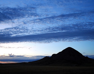
Topography and Landscape Setting
Bear Butte is an isolated,
cone-shaped peak that rises dramatically as a topographic "island" from
the surrounding flat-to-rolling prairie grasslands. It stands
approximately 1,200–1,253.5 feet (366–382 m) above the plains, with a
summit elevation of 4,426 feet (1,349 m) above sea level. This gives it
commanding 360-degree panoramic views from the summit, encompassing the
Black Hills to the southwest, vast prairies stretching across western
South Dakota, and reportedly portions of up to four states on clear
days. The butte's rugged flanks feature steep, rocky slopes with exposed
outcrops, switchbacks on trails, and limited vegetation cover higher
up—exacerbated by a 1996 wildfire that cleared many trees and opened up
expansive sightlines.
The park sits at the northeastern edge of the
Black Hills region, where the landscape shifts from the forested,
higher-relief Black Hills core (part of the Middle Rockies ecoregion)
into the semiarid Northwestern Great Plains, specifically the Pierre
Shale Plains. Highway 79 bisects the park: the eastern section contains
the main butte and summit trail, while the western side includes the
lake, horse camping areas, and portions of the Centennial Trail (the
butte marks its northern terminus). The terrain around the base is open
prairie with gentle undulations, supporting grazing and wildlife
movement.
Geology
Bear Butte is not a classic erosional butte
but a laccolith—an intrusive igneous formation created around 50 million
years ago during the Eocene Epoch. Magma rose from deeper crustal levels
and forcefully intruded into cooler sedimentary rock layers without
fully erupting to the surface (though any volcanic remnants have long
since eroded). This intrusion domed and uplifted the overlying strata,
which subsequent erosion stripped away over millions of years, exposing
the resistant igneous core.
The rock composing the butte is primarily
porphyritic phonolite, a fine-grained igneous rock with larger
phenocrysts (crystals), dominated by alkali feldspar (orthoclase) and
nepheline. Along the flanks, remnants of the uplifted sedimentary cover
remain visible, including tilted beds of Mississippian-age Madison
Limestone and vertical exposures of the Minnelusa Sandstone. Bear Butte
is the easternmost in a line of similar Tertiary igneous intrusions
extending about 50 miles across the northern Black Hills toward Devils
Tower and the Missouri Buttes in Wyoming, all tied to the broader
Laramide Orogeny and Black Hills uplift.
Hydrology
A key
hydrological feature is Bear Butte Lake, a shallow, warmwater body
located west of Highway 79. It covers approximately 215 acres with about
3.25 miles of shoreline and an average depth of only 7 feet (maximum
around 13 feet). The lake supports fishing for northern pike, bullheads,
and crappies, plus boating and a fishing pier. Historically, the lake
area was drained in the late 19th century for attempted farmland before
being restored.
The park lies within the Bear Butte Creek watershed
(part of the Belle Fourche River drainage), which spans diverse
ecoregions from Black Hills highlands to plains. Streams in the broader
watershed are typically small (under 4 m wide), with annual
precipitation of 20–28 inches (mostly April–September). The area
experiences typical prairie hydrology: episodic runoff, variable water
quality influenced by agriculture and rangeland, and groundwater
contributions from the surrounding geology.
Climate and
Environmental Context
The climate is continental with prairie
influences: cold winters (January lows often 10–20°F), warm summers
(July highs 80–90°F), and moderate precipitation (around 15–28 inches
annually, higher near the Black Hills). Winds can be strong on the
exposed butte (gusts exceeding 40 mph), and the summit trail offers
little shade, making it demanding in summer heat or variable weather.
Snowfall averages around 38 inches regionally.
Flora and Fauna
Vegetation reflects the prairie–foothills transition: open grasslands
with prairie grasses, yucca, and wildflowers (especially vibrant
post-fire in spring/summer) dominate the base and lower slopes.
Scattered ponderosa pine and juniper appear on the flanks, with prayer
ties and cloths often adorning trees. The upper butte is rockier and
sparser.
A moderately sized bison herd roams the base (primarily east
of the highway), alongside other wildlife such as deer and various
birds. Visitors are cautioned to maintain distance from bison, as they
are wild and potentially dangerous. The park's location supports a mix
of grassland and foothill species in a broader ecological context of
rangeland (much of the watershed) and forested pockets.
Bear Butte State Park, located about 6 miles northeast of Sturgis,
South Dakota, centers on the striking laccolith known as Bear Butte
(Mato Paha or "Bear Mountain" to the Lakota people). This igneous
intrusion rises more than 1,200 feet (about 366 m) above the surrounding
northern Great Plains prairie, creating a dramatic topographic contrast.
The park blends mixed-grass prairie, shrubby draws, rocky slopes and
cliffs, scattered woodlands, and wetland/riparian zones around Bear
Butte Lake. A major 1996 wildfire cleared much of the timber on the
butte's slopes, resulting in more open vistas, abundant wildflowers in
spring and summer, and a mosaic of recovering vegetation.
The park's
habitats reflect a transition zone between the Great Plains prairie and
the eastern edge of the Black Hills, supporting a mix of prairie,
foothill, and wetland species. Official sources and nearby surveys (such
as the Bear Butte Creek Historic Preserve just south of the park in the
Sturgis area) document significant biodiversity. The preserve alone
recorded 135 plant species (86 native) in a 2021 growing-season survey,
illustrating the rich native flora of the region.
Flora (Plants)
Vegetation varies sharply by elevation, slope, and moisture:
Mixed-grass prairie and base areas: Dominant at the butte's base and
surrounding plains. Hardy grasses include species typical of northern
Great Plains mixed-grass prairie (e.g., western wheatgrass,
needle-and-thread grass, little bluestem). Common forbs and shrubs
include soapweed yucca (Yucca glauca, with its tall flower stalks and
sword-like leaves), big sagebrush (Artemisia tridentata or similar), and
prairie forbs. These provide forage for herbivores and stabilize the
soil.
Slopes, draws, and butte flanks: Ponderosa pine (Pinus
ponderosa) and Rocky Mountain juniper (Juniperus scopulorum) dot the
steeper, rocky areas, often in clusters or along protected draws.
Deciduous trees like green ash (Fraxinus pennsylvanica) appear in
gullies and tree-lined draws. Shrubby species such as skunkbush sumac
and snowberry occur near the summit and trails. The post-fire landscape
has encouraged diverse wildflowers, including pasque flowers (Pulsatilla
patens) and other prairie blooms that carpet the area in spring/summer.
Lake and riparian/marsh zones: Around Bear Butte Lake and associated
creeks, cattails, sedges, and riparian vegetation (willows, cottonwoods,
or other deciduous species) create wetland edges. These support
moisture-loving plants and provide cover for wildlife.
Rocky cliffs
and summit: Sparse vegetation with lichens, mosses, and crevice-adapted
forbs on exposed rock faces. Prayer cloths and offerings hang from trees
along the Summit Trail (a cultural note, but part of the living
landscape). Poison ivy is present on some trails—watch your step.
The park does not have a publicly exhaustive published plant
checklist like some larger parks, but the adjacent Bear Butte Creek
Historic Preserve's 2021 survey (86 native species documented across
five seasonal counts) gives a strong proxy for the area's flora. It
includes a wide array of prairie grasses, forbs, and woody plants
typical of the northern plains.
Fauna (Animals)
The park
supports a rich array of wildlife, enhanced by its position as a
migration stopover, prairie habitat, and wetland oasis.
Mammals
American bison (buffalo): A small herd roams the base of the butte
(primarily on the east side of Highway 79). These are wild animals—keep
a safe distance and do not approach or feed them.
Deer: Mule deer and
white-tailed deer are common on trails and in draws.
Pronghorn
antelope: Frequently seen in the open prairie grasslands.
Other
mammals: Porcupines (especially in wooded areas), coyotes, foxes,
jackrabbits, prairie dogs (nearby), ground squirrels, chipmunks, mice,
and raccoons. Smaller rodents support the food web.
Birds
Bear
Butte State Park (including Bear Butte Lake) is a notable birding
hotspot, with over 150–188 species recorded across eBird hotspots for
the park and lake. The lake and marsh serve as a key migration and
breeding area for waterfowl and shorebirds (best March–October).
Waterfowl and waterbirds (Bear Butte Lake): American White Pelican,
various ducks (Blue-winged Teal, American Wigeon, Cinnamon Teal,
Bufflehead, Mallard, Gadwall), American Avocet, Eared Grebe, Belted
Kingfisher, American Bittern (nesting on the island, viewable from group
camp), plovers (Black-bellied, Semipalmated), rails, and occasional
rarities like Clark’s Grebe or Long-tailed Duck.
Upland and prairie
birds: Sharp-tailed Grouse and Gray Partridge (flocks near campground),
Lark Sparrow, Field Sparrow, Spotted Towhee, Mountain Bluebird
(nesting), Tree Swallow, prairie songbirds.
Raptors and others:
Peregrine Falcon, Prairie Falcon, Long-eared Owl (in wooded draws), Rock
Wren (on rocky slopes/cliffs), Rusty Blackbird (fall), Gray-crowned
Rosy-Finch (sporadic winter near summit/Visitor Center). Nearby Fort
Meade Reservoir adds more wetland species.
A 2020/2021 Christmas
Bird Count along Bear Butte Creek (adjacent) added species like Canada
Goose, Mallard, Green-winged Teal, Sharp-shinned Hawk, Wild Turkey,
Wilson’s Snipe, Downy Woodpecker, Northern Flicker, Blue Jay, American
Crow, Black-capped Chickadee, White-breasted Nuthatch, House Finch, and
American Goldfinch.
Reptiles and Amphibians
Prairie
rattlesnakes are common on trails and rocky slopes—wear sturdy boots and
stay on paths. Other snakes include non-venomous garter snakes,
bullsnakes, and ring-necked snakes. Amphibians (toads, frogs) occur
around the lake and wet areas, though less documented in public sources.
Fish and Aquatic Life
Bear Butte Lake offers fishing (South
Dakota license required) for northern pike, black bullhead, black
crappie, yellow perch, channel catfish, largemouth bass, walleye, and
others. The lake is a mix of natural and managed fishery.
Other
Wildlife Notes
Insects and invertebrates (butterflies, bees, prairie
specialists) thrive in the wildflower-rich areas but are not heavily
cataloged publicly. The park's location makes it excellent for observing
seasonal changes—spring wildflowers and bird migration, summer prairie
blooms and bison activity, fall migration, and winter hardy species.
Safety and Respect: The park is sacred to many Native American tribes—do
not disturb prayer offerings (cloths, tobacco) in trees. Bison are wild
and unpredictable. Pets are restricted on the Summit Trail, and horses
are only allowed west of Highway 79.