Location: Wiltshire Map
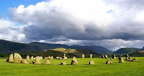
Avebury, located in Wiltshire in southwest England, is one of the world's most impressive and largest prehistoric monuments, a vast Neolithic henge and stone circle complex constructed roughly between 2850 BC and 2200 BC. Enclosing part of the modern village of Avebury within its huge circular earthwork bank and ditch, it features the largest megalithic stone circle in Britain (originally about 100 sarsen stones, some weighing over 40 tons), which in turn contains two smaller inner stone circles. Unlike Stonehenge, visitors can freely wander among and touch the ancient stones in this living landscape, which forms part of a broader sacred ceremonial complex including nearby Silbury Hill and other sites. Designated a UNESCO World Heritage Site alongside Stonehenge, Avebury blends ancient mystery with everyday village life, attracting tourists, historians, and modern pagans alike for its scale, accessibility, and enduring spiritual aura.
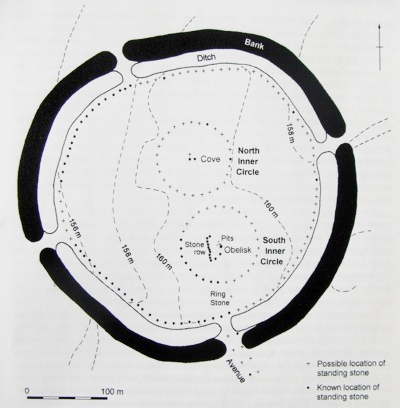
Overall Layout and Scale
The monument centers on a massive henge—a
circular earthwork enclosure formed by an external bank and an internal
ditch. This henge measures approximately 347–421 meters (about
1,140–1,380 feet) in diameter, with a circumference exceeding 1
kilometer (roughly 1.3–1.35 km). It encloses an area of about 11.5
hectares (28.5 acres). The bank, built from chalk dug out of the ditch,
originally rose dramatically (perhaps 5–6 meters or more above the
surrounding land, with the ditch originally 9–11 meters deep and up to
21–23 meters wide at the top). Today, the bank survives to about 5
meters high in places, though the ditch has partially silted up.
The
henge is not perfectly circular and features four causewayed entrances
(roughly north, south, east, and west), which break the continuous bank
and ditch. These entrances allow access and were likely processional
thresholds. Modern roads (including the A4) and the village of Avebury
itself sit partially inside and across the henge, with houses, a church,
and paths weaving among the stones—a unique living integration of
prehistoric monument and modern settlement.
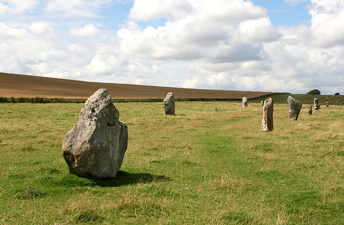
The Stone Circles
Inside the henge lies the largest prehistoric stone circle in Europe
(Britain's largest), along with two smaller inner circles. All stones
are local sarsen (a hard sandstone), left rough and unshaped, varying in
height, width, and profile—some tall and pillar-like, others shorter and
broader. Many weigh 20–100 tons.
Outer Stone Circle: This massive
ring sits just inside the ditch and closely follows its curve. It has a
diameter of about 331.6 meters (roughly 1,088 feet). Originally, it
comprised around 98–100 standing stones, irregularly spaced but forming
a near-complete circuit. Today, about 30 stones remain upright, with
another 16 or so positions marked by concrete pillars; many others were
toppled, buried, or re-erected during 20th-century excavations (notably
by Alexander Keiller in the 1930s). The stones at the entrances
(especially north and south) are among the tallest and most imposing.
Northern Inner Circle: Located in the northern half of the outer circle,
this has a diameter of about 98 meters (322 feet). It originally
included around 27–30 stones, but only a few survive upright or fallen.
At its center stands the Cove—a dramatic setting of three (originally
perhaps four) massive sarsen stones arranged in a U-shape or open
square/cove, with the opening facing northeast. These stones are
enormous (one of the largest remaining weighs around 100 tonnes), and
this feature may be one of the earliest parts of the complex (possibly
~3000 BC).
Southern Inner Circle: In the southern half, this measures
about 108 meters (354 feet) in diameter. It once held around 29 stones
and featured a central obelisk (a massive monolith originally ~5.5–6.4
meters tall, destroyed in the 18th century; its base is now marked).
Additional features include a rectangular or square arrangement of
smaller stones known as the Z-feature (or similar settings). Geophysical
surveys have revealed evidence of a possible larger square megalithic
structure here, potentially one of the site's earliest elements.
The Avenues
Two (possibly three) ceremonial avenues of paired
standing stones radiate from the henge entrances, linking Avebury to
other monuments in the landscape. These were likely processional routes.
West Kennet Avenue (the best-preserved): Runs ~2.4–2.5 km southeast
from the henge's southeast entrance to the Sanctuary (a timber-and-stone
circle on Overton Hill). It consists of a double row of stones forming a
corridor ~15–20 meters wide, with roughly 100 pairs originally (stones
spaced 20–30 meters apart, alternating tall upright "male" and squat
"female" forms, per antiquarian interpretations). About 27 stones still
stand, with others marked. The stones generally decrease in size farther
from the henge.
Beckhampton Avenue: Extends ~1.7 km southwest from
the western entrance toward Beckhampton Longstones (or Longstones Cove,
where two massive stones—"Adam and Eve"—still stand). This avenue is far
less visible today, with most stones removed or buried, but excavations
have confirmed its path and sockets.
A possible third avenue
(sometimes called the Silbury or another route) has been suggested in
surveys, but the two main ones are the clearest.
Construction
Phases and Context
The layout evolved in phases rather than as a
single build: the central cove and inner elements may predate the outer
circle and henge bank/ditch, with avenues added later (~2400 BC). The
entire complex was part of a ritual landscape that includes Silbury Hill
(Europe's largest artificial prehistoric mound, ~39.5 m high, ~1.5 km
south), West Kennet Long Barrow, Windmill Hill causewayed enclosure, and
more—creating a network of aligned ceremonial sites.
The stones'
irregular placement and the henge's vast scale emphasize procession,
enclosure, and astronomical/ritual alignments (e.g., the Cove's
northeast orientation). Much of what we see today results from
20th-century restoration, but the core prehistoric layout remains
awe-inspiring in its monumentality.
Early Landscape and Pre-Neolithic Context (Mesolithic to Early
Neolithic, c. 8500–3000 BC)
The Avebury area has evidence of
human activity stretching back to the Mesolithic period (c.
8500–4000 BC), when the landscape was largely wooded (oak, elm,
hazel, alder, lime) and hunter-gatherers left flint tools. Around
4000 BC, Neolithic farmers arrived from Europe, clearing land for
crops (wheat, barley) and livestock (cattle, sheep, pigs, goats). By
c. 3700 BC, settled communities had formed, with enough surplus
labor for large-scale communal projects.
Key early monuments in
the landscape include:
Windmill Hill causewayed enclosure (c.
3700–3200 BC): A large tribal gathering place for ceremonies, trade,
or feasts.
West Kennet Long Barrow (c. 3600–2300 BC): A 100m-long
communal tomb used for burials over centuries.
Recent
research (2017–2019, "Living with Monuments Project") suggests the
site of what became Avebury’s Southern Inner Circle may have
originated around an early Neolithic wooden house (c. 3700–3500 BC),
later monumentalized with a unique square setting of standing stones
(possibly a "foundational" structure). This implies Avebury’s story
began as the memorialization of a modest dwelling, with later
circles built around it like "ripples from a pond."
Construction of the Main Henge and Stone Circles (c. 2850–2200 BC)
The core monument—the henge and stone circles—was built and modified
over several centuries during the Late Neolithic, in the third
millennium BC. Exact phasing remains debated due to limited dating
evidence, but construction spanned roughly 2850–2200 BC (with some
estimates placing the henge by the mid-third millennium BC).
The henge: A massive circular earthwork (347m diameter, over 1km
circumference) with an internal ditch (originally up to 11m deep,
dug with antler picks) and external bank of chalk. The ditch was
internal (not defensive), creating a sacred, enclosed space. The
bank was irregular, reflecting piecemeal labor by different groups.
Outer stone circle: Originally about 98–100 massive sarsen stones
(local sandstone, some over 40 tons and 4m+ high), forming the
largest stone circle in Britain/Europe. Stones were unshaped but
positioned deliberately.
Inner stone circles: Two separate
circles inside the henge. The Northern Inner Circle (c. 98m
diameter) included a central "cove" of three stones facing
northeast. The Southern Inner Circle (c. 108m diameter) once had a
tall central monolith (the "Obelisk," later destroyed).
Avenues:
Two processional stone avenues linked the henge to other sites. The
West Kennet Avenue (south, c. 2.5km long with paired stones)
connected to the Sanctuary on Overton Hill. The Beckhampton Avenue
(west) is less preserved.
Nearby Silbury Hill (c. 2470–2350
BC, built rapidly over a short period) stands 1.5km south: a
stepped, chalk mound 39m high and 160m across—Europe’s largest
prehistoric artificial mound, possibly a territorial marker or
symbolic focal point, though not a burial site.
The entire
complex likely served as public "theatres" for rituals expressing
world order, community identity, relationships with gods/ancestors,
and authority. Theories include seasonal gatherings, fertility rites
(suggested by phallic carvings and chalk objects), processions, or
astronomical alignments, though no single purpose is proven. The
site evolved over time, possibly shifting from earlier timber
structures to permanent stone.
Later Prehistory, Abandonment,
and Reuse (Bronze Age onward)
By c. 2200–1800 BC (early Bronze
Age), major construction ended, and the monuments were gradually
abandoned as new practices (e.g., individual round barrow burials
with metal goods) emerged. Iron Age and Roman activity was
limited—mostly farming, with some Roman visitors leaving pottery.
The site was not a settlement but a ceremonial center ("clean" site
with ritual rather than domestic debris).
Medieval Period (c.
AD 500–1500): Village and Destruction
An Anglo-Saxon village grew
up inside the henge from the 6th–10th centuries, with a church and
grubenhaus (sunken-floored hut). Some stones gained folk names
linking them to the devil (e.g., Devil’s Chair). From the late
Middle Ages (c. 1300s), Christian villagers systematically toppled,
buried, or smashed stones—possibly viewing them as pagan or simply
clearing land for farming/building. Fire, water, and hammers were
used to break sarsens.
A famous discovery during 1930s
excavations was the "barber-surgeon" skeleton (c. 1320–1325) crushed
under a fallen stone, with coins, scissors, and a lancet in his
pouch—likely killed while helping demolish it. The Black Death
(1349) may have slowed further destruction.
Antiquarian
Rediscovery (17th–18th Centuries)
In 1649, antiquarian John
Aubrey "rediscovered" the site while hunting and surveyed it in
1663, producing early plans. William Stukeley (1719–1724) documented
it extensively in Abury, a Temple of the British Druids (1743),
interpreting it (incorrectly) as a Druid temple and linking it to
Christianity; he named stones and recorded ongoing destruction.
20th-Century Excavations and Restoration
Major modern
archaeology began with Harold St George Gray’s ditch excavations
(1908–1922), revealing antler picks, pottery, flint, and human
bones. Wealthy archaeologist Alexander Keiller (of Keiller marmalade
fame) bought land and the manor in the 1920s–1930s, excavated
extensively (1934–1939), re-erected dozens of buried stones, and
placed concrete markers for missing ones. He cleared village
buildings and created the Alexander Keiller Museum. World War II
halted full plans, but his work gives Avebury its current restored
appearance. Further surveys (1960s–2000s) and geophysics (2003,
2017) revealed buried stones and the square setting.
Modern
Era and Significance
The National Trust has owned and managed
much of the site since 1943 (now in partnership with English
Heritage). It attracts hundreds of thousands of visitors yearly for
its serene atmosphere, sheep-grazed fields, and accessibility
(unlike Stonehenge). Contemporary pagans use it for rituals. Ongoing
research, including the Living with Monuments Project, continues to
uncover details.
Getting There and Parking
By car (recommended): Avebury lies about
6 miles west of Marlborough on the A4361. The main National Trust
pay-and-display car park (postcode SN8 1QT) is centrally located
southeast of the village. Cash is preferred (machines may not take cards
easily due to poor signal); expect around £7 for the day or £4 after
3pm. National Trust members park free; English Heritage members also get
free parking but may pay for the Manor.
Public transport: Train to
Swindon, then bus 49. It drops near The Red Lion pub in the village.
Note: Limited mobile signal in the area—plan ahead. The car park has
gates with posted hours; check to avoid being locked in.
When to
Visit
The stone circle and outdoor sites are open dawn to dusk
year-round, free to access. Indoor sites like the Alexander Keiller
Museum and Avebury Manor have seasonal hours (typically 10am–5pm or
similar—check the National Trust site).
Best times:
Spring
(March–April): Mild weather, fewer crowds, beautiful landscapes.
Summer (May–October): Longer days for exploring, but peak season means
more visitors.
Avoid major pagan festivals/solstices/equinoxes
(especially summer solstice) if you prefer quieter visits—crowds gather
for ceremonies.
Early morning or late afternoon/evening offers
the best light, fewer people, and a more atmospheric feel. Winters are
colder and wetter but can be peaceful.
What to See and Do
(In-Depth Itinerary)
Avebury Stone Circle & Henge (Core Experience,
1–2+ hours)
Walk the full ~1-mile circuit around the massive bank and
ditch. The circle originally had about 100 stones; many remain. Explore
the four quadrants (roads cut through like an X). Touch the stones, sit
among them, and absorb the scale—it's far less restricted than
Stonehenge. Sheep often graze here; keep dogs on leads.
Alexander
Keiller Museum & Old Farmyard (30–60 minutes)
Start here for context.
The museum (in the Stables and Barn) displays artifacts and explains the
Neolithic history. The Old Farmyard has the visitor reception, shop,
cafe (Circles Cafe with sandwiches, soups, cakes, cream teas), and
toilets. Tickets required for the museum; free for members.
Avebury Manor & Garden (1 hour)
16th-century manor with rooms
decorated in different historical periods (interactive and atmospheric).
The gardens are a highlight—formal, beautiful, and relaxing. Check
reopening status as of 2026 (it had flood repairs). Entry fee; free for
NT members.
Nearby Sites (Highly Recommended, Walk or Short
Drive):
West Kennet Long Barrow (30-min walk or 5-min drive): One of
Britain's finest chambered tombs (~3650 BC). Enter the chambers—magical,
especially at dawn/dusk. Lay-by parking.
Silbury Hill: Europe's
largest man-made prehistoric mound. View from the base (can't climb).
Short walk from a small car park.
West Kennet Avenue: Stone rows
leading from the circle.
Windmill Hill: Less-visited Neolithic site
with barrows—great for a quiet picnic (1.5 miles walk, no car access).
Other options: St. James' Church (free, in the village), local shops
(crystals, books, gifts), or longer walks on the Ridgeway trail.
Practical Tips
Duration: 2–3 hours for the core village/circle; a
full day or overnight for the wider landscape.
Footwear & Weather:
Paths can be uneven, muddy, or grassy. Wear sturdy shoes/boots. Bring
layers—English weather changes quickly. Sunscreen/rain jacket essential.
Facilities: Toilets at Old Farmyard. Limited options elsewhere. Picnics
welcome (tables in Farmyard or quiet spots like Windmill Hill). Nearby
pubs: Red Lion (in the circle, touristy) or better Waggon & Horses in
Beckhampton.
Accessibility: Some paths are uneven; Blue Badge parking
available. Contact NT for details (01672 539250). Dogs welcome on leads
(2-pawprint rated).
Membership Savings: National Trust or English
Heritage cards offer great value (free parking + entries).
Etiquette:
Respect the sacred site—no climbing stones excessively, leave no trace
(especially avoid "ritual rubbish" like crystals or offerings that can
damage the site). Drones restricted.
Crowds & Solstice: Special
advice on NT site for summer solstice visits.