Constructed: South Moravian Region Map
Area: 63 km² (24 sq mi)
Podyjí National Park, nestled in the South Moravian Region of the Czech Republic, is the smallest and youngest of the country's four national parks, renowned for its exceptionally well-preserved river valley ecosystem. Bordering Austria's Thayatal National Park, the two form a unique transboundary "Inter-National Park" that protects a continuous natural landscape along the Dyje (Thaya) River. Covering a core area of 63 square kilometers (24 sq mi) with an additional 29 square kilometers (11 sq mi) buffer zone, it spans elevations from 214 to 534 meters (702 to 1,752 ft) and is centered around coordinates 48°51′N 15°54′E. This park is celebrated for its near-natural forests, diverse habitats, and status as one of Central Europe's most ecologically significant sites, often described as a "wild piece of Czech nature" with minimal human intervention. Its unique river canyon, lush woodlands, and rare species make it a haven for biodiversity, while its proximity to towns like Znojmo and Vranov nad Dyji enhances its appeal as a less-crowded alternative to more famous Czech natural areas.
Geological and Prehistoric Foundations
The landscape’s foundations
trace back to the Bohemian Massif (Český masiv), one of Europe’s oldest
geological formations, consisting primarily of Proterozoic crystalline
rocks like gneiss and granitoids. In the Tertiary period (around 11
million years ago), retreating seas and the uplifting of the massif
shaped the terrain. The Dyje River then rapidly incised into the
landscape, carving a deep valley (up to 100–220 meters in places) with
steep slopes, rocky amphitheaters, cliffs, and meanders.
During the
Pleistocene (Ice Age), periglacial processes created characteristic
blockfields (kamenná moře) — vast accumulations of boulders and stones
on slopes. Pseudokarst caves and unique microclimates (e.g., ice caves
or ledové sluje) also formed. These features support diverse habitats,
from cool, shaded forests to warm, sunny steppe-like slopes.
Archaeological evidence shows human presence dating back about 7,000
years, particularly around the Šobes vineyard area. The region’s
strategic river valley likely supported early settlements, though
intensive modification came later.
Medieval to Early Modern Human
Influence
In the Middle Ages, the area was shaped by agriculture and
settlement. Original oak forests were cleared for grazing, leading to
the creation of heathlands and steppe-like meadows (especially in the
southeastern part near Znojmo-Hnanice-Havraníky). These open landscapes,
some of the largest in the Czech Republic, are secondary habitats
maintained by centuries of pastoralism.
Notable historical sites
include:
Nový Hrádek (New Castle) ruins, built in the 14th century by
John Henry of Luxembourg.
Medieval vineyards like Šobes, known for
its exceptional microclimate and wine production.
Other castles,
mills, and fortifications along the river.
Tourism began
developing in the second half of the 19th century, with visitors drawn
to the romantic river valley, mills, and scenic spots. A paper factory
and summer resorts existed near Šobes.
20th Century: Iron Curtain
Paradox and Protection Efforts
The most transformative period came
during the Cold War. In 1951, the Iron Curtain turned much of the Dyje
valley into a heavily militarized, inaccessible border zone between
Czechoslovakia and Austria. Civilian access was banned for nearly 40
years (roughly 1950s–1989), with watchtowers, barbed wire, signal roads,
plowed strips, and mines enforcing the divide.
This isolation, while
tragic for locals, proved a boon for nature. Human interference was
minimal, allowing forests to regenerate, wildlife to thrive, and
ecosystems to remain exceptionally intact — one of the best-preserved
river valleys in the Czech Republic (about 42 km of nearly uninhabited
gorge).
In 1978, the Protected Landscape Area (CHKO) Podyjí was
established over a larger area (103 km²), though much remained
off-limits to the public. After the Velvet Revolution in 1989, the
border opened, and the Iron Curtain was dismantled. This enabled serious
efforts to elevate protection.
Establishment as a National Park
(1991)
The park was officially declared on 10 May 1991 (some sources
note 1 July 1991 for full effect) by Czech Government Order No. 164/1991
Sb. It incorporated the most valuable cores of the former CHKO Podyjí,
which was dissolved. A buffer zone covers much of the remaining former
CHKO area.
It became Moravia’s first (and only) national park and the
Czech Republic’s smallest. The primary goal was to protect the unique
geomorpohology, near-natural forests, biodiversity, and the Dyje canyon.
Tomáš Rothröckl served as the first director for 33 years (1991–2024);
Pavel Müller succeeded him around 2025.
In 2000, Austria established
Nationalpark Thayatal on its side, creating a transboundary protected
area. Cooperation agreements (e.g., a 1999 treaty) facilitate joint
management.
Remnants of the Iron Curtain, such as at Čížov (the
park’s visitor center is in a former border patrol building), are
preserved as memorials.
Modern Era and Significance
Since
1991, the park has focused on strict nature protection (IUCN Category
II), with 84% forest cover dominated by deciduous and mixed woods. It
supports exceptional biodiversity, including rare plants (77 protected
species, 18 orchids), fungi, and animals (e.g., black stork, otters,
beavers, various bats). Heathlands and vineyards like Šobes add cultural
value.
In 2026, the park celebrated its 35th anniversary. It remains
a key site for hiking, education, and cross-border tourism, balancing
conservation with limited, sustainable public access (no water sports on
the river, regulated trails).
Location and Boundaries
The park stretches roughly 15 km in length
and 8 km in width, primarily between the towns of Znojmo (to the west)
and Vranov nad Dyjí (to the east). It follows the course of the Dyje
River (known as the Thaya in German/Austrian contexts), which serves as
the international border for much of its length.
It is situated at
the southeastern edge of the Bohemian-Moravian Highlands (Českomoravská
vrchovina) and represents a transition zone between the Bohemian Massif
and the Carpathian region.
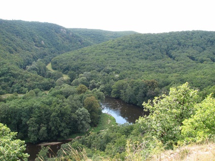
Topography and Geomorphology
The
defining feature of Podyjí is its deep, canyon-like river valley, which
is exceptionally well-preserved and considered one of the finest
examples of a near-natural river valley in Central Europe.
The Dyje
River flows for about 40 km through the park in a thickly forested,
meandering valley.
The valley reaches depths of up to 220 meters
(average around 150 m), creating dramatic scenery with steep rocky
slopes, cliffs, rock pillars, gorges, and scree (talus) slopes.
The
terrain includes a mosaic of rocky amphitheaters, steep walls, extensive
scree fields, difficult-to-access gullies, alluvial meadows along the
river, and sunny forest-steppe areas.
Elevation ranges from 214 m at
the river level to 534 m on the upper plateaus.
The landscape
features numerous meanders, rocky outcrops, and pseudokarst phenomena
(such as ice caves). The upper plateaus were historically cleared for
agriculture and now support grasslands, contrasting with the densely
forested valley slopes.
Geology
The park sits on the boundary
between two major geological units, leading to high diversity:
Western part: Dominated by metamorphic rocks, primarily phyllites and
gneisses.
Central part: Features crystalline limestones.
Eastern
part: Predominantly granites.
This complex bedrock, shaped by the
uplifting of the Czech Massif and long-term erosion (particularly since
the Tertiary period, around 11 million years ago when seas retreated),
has created varied soil types and microhabitats. The river’s erosive
power has carved out the deep valley and exposed these formations.
Climate
Podyjí experiences a relatively mild, warm climate
influenced by its position in southern Moravia and the protective effect
of the valley. The varied topography creates significant microclimatic
differences: cooler, more humid conditions on north-facing slopes and in
the valley bottom versus warmer, drier, sun-exposed south-facing slopes
that support thermophilous (heat-loving) species. This climatic variety
contributes greatly to biodiversity.
Hydrology
The Dyje River
is the central hydrological feature, draining the park. Its flow is
influenced by the Vranov hydroelectric dam upstream, which can cause
fluctuations. The river supports wetlands, reed beds, and alluvial
habitats. Smaller tributaries and gullies add to the complexity of the
drainage system.
Habitats and Vegetation
The geological and
topographic diversity supports a rich mosaic of habitats: forests (the
dominant type), grasslands, shrublands, rocky areas, arable land, and
inland wetlands.
Forests: Transition from submontane beech forests
(with yew) in the west to thermophilous oak forests in the east.
Hornbeam, alder, and mixed stands are also present.
Open areas: Dry
grasslands, steppe remnants, heathlands (with heather), and
forest-steppes with thermophilous plants.
Notable species include
around 1,300 vascular plants, with many protected or rare ones (e.g.,
orchids, cyclamen, pasque flower, mulleins, and Daphne cneorum).
The park lies at the intersection of different biogeographical regions
(Hercynian and Pannonian influences), allowing species from both Central
European forests and southeastern European thermophilous areas to
coexist.
Overall Geographical Significance
Podyjí’s geography
is remarkable for packing high geodiversity and biodiversity into a
compact area. The combination of a deeply incised, meandering river
valley with steep rocky terrain, varied geology, and microclimates has
preserved habitats that were more widespread before intensive human
modification of the Central European landscape. Its transboundary nature
enhances ecological connectivity. The park also includes cultural
elements like vineyard terraces (e.g., the renowned Šobes vineyard),
castle ruins, and historical sites integrated into the natural
landscape.
The park's biodiversity is exceptional, hosting a rich array of flora and fauna in its near-natural state. Flora includes 77 plant species in the valley alone, with dominant forests of oak (acidophilous and temperate), hornbeam, beech, and alder, alongside perennials like cyclamen, mulleins, pasque flower, and 18 species of orchids. Riverbeds feature reed-beds and willow shrubs, while upper plateaus support grasslands. Fauna is equally diverse, with 152 bird species, including key ones like the Syrian woodpecker (Dendrocopos syriacus) and barred warbler (Sylvia nisoria), qualifying it as an Important Bird Area (IBA) by BirdLife International over 76.66 square kilometers. Mammals number 65 species, and reptiles include seven, such as the tree snake and green lizard. This variety underscores Podyjí's role as a biodiversity hotspot in Central Europe, with rare and endangered species thriving in its protected habitats.
Conservation efforts in Podyjí focus on maintaining the park's natural processes, with land designated primarily for nature protection, research, forestry, and limited agriculture. Established to preserve the area's extraordinarily valuable ecosystems, the park emphasizes minimal intervention to allow wilderness recovery, including in zones like the 254-hectare wilderness area highlighted for its resilience. Cross-border cooperation with Thayatal enhances protection against threats like climate change and invasive species. Ongoing projects include habitat restoration and monitoring, supported by its IBA status and potential UNESCO recognition for sites like the Šobes vineyards. These initiatives ensure the park remains a model of sustainable conservation in a densely populated region.
Best Time to Visit
Optimal periods: April–June and
September–October. Mild temperatures (15–22°C/59–72°F), longer daylight,
blooming wildflowers in spring, and colorful foliage in autumn. Fewer
crowds and less rain than peak summer.
Summer (July–August): Warm to
hot (can exceed 30°C/86°F) and more humid; popular for swimming/boating
on the Vranov reservoir but busier on weekends.
Winter: Possible for
cross-country skiing or quiet walks, but limited access, shorter days,
and potential snow/ice on trails.
Pro tip: Late May or early October
for the best balance of weather, nature, and solitude.
How to Get
There
Main gateway: Znojmo (historic town with train/bus connections
from Brno ~1 hour, Prague ~2.5–3 hours).
By car: Easy access; ~1 hour
from Brno. Parking available in villages like Hnanice, Čížov, Havraníky,
or at trailheads (some paid, ~€5–10/day).
Public transport: Buses
from Znojmo to villages around the park (e.g., Hnanice, Čížov). Services
can be infrequent—check schedules.
From Austria: Cross-border trails
connect to Hardegg.
Getting Around & Trails
No entrance fee.
Stay on marked trails (color-coded; note that markings can occasionally
change). The park excels for hiking, cycling (prefer mountain/trekking
bikes), and horseback riding. No water sports on the Dyje River itself.
Popular trails & highlights:
Šobes Vineyard loop (from Hnanice):
Swinging footbridge, top European vineyard on a sunny slope—great for
wine tasting (open spring–autumn).
Čížov to Hardegg: Visitor center,
Iron Curtain remnants, views of Hardegg Castle (Austria).
Thaya
Valley Path (~10 km, moderate): River views, meanders.
Smuggler’s
Trail (high above the Dyje): Scenic, between Vranov and Čížov.
Viewpoints: Vraní skála (Crow Rock), Nine Mills lookout, various canyon
overlooks.
Longer options: Multi-day ridge or valley routes combining
viewpoints, ruins (e.g., Nový Hrádek), and villages.
Trails range
from easy riverside strolls to moderate hikes with steep sections.
Download maps from the official site or buy locally. Apps like Komoot or
AllTrails are useful.
Visitor Centers:
Main: Čížov (former
customs house) — exhibits, info, Iron Curtain memorial. Open seasonally
(e.g., weekends in spring/autumn, daily in summer).
Info point at
Vranov Chateau in peak season.
What to See & Do
Nature: Dyje
River canyon/meanders, steppe slopes (butterflies, lizards, orchids),
forests, moors (Fládnitzké, Havranické).
History: Iron Curtain sites
(Čížov), castle ruins (Nový Hrádek), Vranov nad Dyjí Chateau &
reservoir.
Wine: Šobes and surrounding vineyards—tastings available.
Wildlife: Birdwatching (dawn/dusk), green lizards, bats, deer. Be
patient and quiet.
Cross-border: Hike into Thayatal NP for
Austrian-side valley views.
Practical Tips
Gear: Sturdy hiking
shoes (some rocky/steep sections), layers, rain jacket, water, snacks,
binoculars, sun protection. Trails can be slippery after rain.
Food &
Drink: Limited inside the park—pack lunches or eat in
villages/Znojmo/Vranov. Local Moravian wines and cuisine (try in
Znojmo). Groceries are affordable.
Accommodation: Base in Znojmo
(full range: hotels, guesthouses, hostels) or Vranov nad Dyjí. Villages
like Hnanice, Havraníky, or Lukov offer pensions/campsites. Wild camping
is prohibited.
Costs: Very budget-friendly. Free entry; daily budget
€20–50 including food/accommodation/transport (excluding major
splurges).
Rules & Safety: Stick to trails, no littering, no picking
plants, respect quiet zones. Watch for ticks (common in Czech forests).
Moderate difficulty overall but prepare for elevation changes. Rangers
patrol.