Location: Republika Srpska Map
Area: 175 km2
Sutjeska National Park is the oldest national park in the
Republic of Srpska and Bosnia and Herzegovina. Sutjeska became a
national park in 1962 and covers an area of 17,250 ha. The nearest
town is Foča. It is located on the main road route
Belgrade-Višegrad-Foča-Tjentište-Bileća-Trebinje-Dubrovnik.
One of the four last remaining rainforests in Europe is located here
- Perućica. Sutjeska is also home to the highest mountain peak in
the Republic of Srpska, Maglić 2386 m above sea level.
Mount
Maglić is located on the border of Republika Srpska and Montenegro
and can be approached from the national park, which represents a
great challenge for mountaineers, alpinists and similar nature
lovers. The river Sutjeska has cut its way through the canyon for
many years and flows through the very heart of this national park.
Its mountains, lakes, rivers, forests and preserved wilderness are
among the most magnificent in Europe. These Dinarides extend deep
into the Balkan Peninsula, all the way to Prokleti on the border
with Montenegro and Albania.
In the Sutjeska National Park,
in a relatively small area, a huge treasure of flora and fauna is
concentrated. That is why this area was and still is very attractive
to many scientists, botanists, geologists, zoologists and forestry
experts. The rich flora contains over a hundred species of edible
mushrooms, as well as a large number of rare, sensitive and
endangered species.
The animal world is also extremely rich.
Almost all the species typical of the Balkan mountain area live in
dense forests and on mountain slopes. 114 species of birds have been
recorded (in 2002), although it is believed that there are more. Of
the 114 recorded species, 61 nest in the Sutjeska National Park, 32
species visit the park every summer, while 16 species belong to
migrants who pass through here in autumn and spring. Five species
only appear in the national park in winter. The list of birds also
includes 9 species of woodpeckers, which represents 90% of this
family in Europe.
This difficult terrain helped the Partisans
defend against the Germans in the decisive battle, known as the
"Fifth Enemy Offensive" or the Battle of Sutjeska. The Battle of
Sutjeska took place in 1943 and is considered one of the most
difficult battles of the Second World War on the territory of the
former Yugoslavia.
On that occasion, in 1971, a monumental
monument to fallen soldiers was erected in Tjentište as part of the
"Valley of Heroes" memorial complex, which is located next to the
main road Foča - Tjentište - Bileća.
Ancient and pre-modern background
The region of Sutjeska has been
shaped over millennia by the collision of the Dinaric Alps and glacial
processes that carved out deep valleys, including the dramatic valley of
the Sutjeska River itself. Long before modern borders existed, this
mountainous terrain was sparsely inhabited by Illyrian tribes, later
Roman frontier communities, and medieval Slavic populations.
During the medieval Bosnian kingdom (14th–15th centuries), the area lay
near important trade and communication routes connecting the Adriatic
coast with inland Bosnia. Evidence of medieval settlements, fortified
sites, and necropolises with stećci (carved tombstones) can still be
found in the wider region, reflecting a long continuity of human
presence adapted to harsh mountainous conditions.
Under Ottoman
rule (15th–19th centuries), the surrounding forests and high pastures
were used for seasonal livestock grazing, timber extraction, and limited
agriculture. The rugged terrain meant that large-scale settlement
remained minimal, helping preserve the area’s ecological richness.
Early 20th century: conservation ideas and shifting borders
By
the early 20th century, under Austro-Hungarian administration
(1878–1918), forestry management became more systematic. The region’s
old-growth forests—especially around Perućica, one of Europe’s last
remaining primeval forests—began to attract attention from scientists
and foresters.
After World War I, the area became part of the
Kingdom of Yugoslavia. Although no formal protected area existed yet,
discussions about forest conservation began to emerge, especially as
industrial logging expanded elsewhere in the Balkans.
World War
II: the Battle of Sutjeska (1943)
The defining historical event of
the park is the Battle of Sutjeska, fought in May–June 1943 during World
War II. This battle is one of the most significant and brutal
engagements of the Yugoslav Partisan resistance movement led by Josip
Broz Tito.
What happened
Axis forces (German, Italian,
Bulgarian, and Ustaše units) launched a large-scale offensive known as
Operation Schwarz.
Their goal was to encircle and destroy Tito’s
Partisan army in the mountainous terrain of eastern Bosnia.
Around
22,000 Partisans were trapped in the Sutjeska valley against a much
larger Axis force (over 120,000 troops).
The breakthrough
Despite being heavily outnumbered and suffering extreme shortages of
food, medicine, and ammunition, the Partisans attempted a desperate
breakout through the rugged mountains and river gorges. Tito himself was
wounded during the fighting.
The battle resulted in enormous
casualties—especially among Partisan medical units and the wounded—but a
portion of the force succeeded in escaping encirclement, preserving the
core of the resistance movement.
Historical significance
The
Battle of Sutjeska became a foundational myth of Yugoslav socialist
history, symbolizing:
survival against overwhelming odds
unity of
diverse Yugoslav peoples
resistance to fascism
After the war, the
site was turned into a major memorial landscape.
Post-war
Yugoslavia and creation of the National Park (1962)
In the post-World
War II period, the Socialist Federal Republic of Yugoslavia actively
promoted natural conservation alongside ideological commemoration.
In 1962, Sutjeska was officially declared a national park, making it
the oldest national park in Bosnia and Herzegovina.
Its creation
had a dual purpose:
Environmental protection
Preservation of
Perućica rainforest
Protection of high-mountain ecosystems (Maglić,
Volujak, Zelengora ranges)
Commemoration
Institutionalizing the
memory of the Battle of Sutjeska
Developing memorial tourism
The Tjentište Memorial Complex
In the 1970s, the Yugoslav government
constructed one of the most striking WWII memorials in the Balkans: the
Valley of Heroes (Tjentište Memorial Complex).
Designed in a
monumental brutalist style, it includes:
massive concrete wing-like
structures symbolizing breakthrough and victory
a central
commemorative space
sculptural reliefs and underground exhibition
areas
This site became a key destination for school visits, state
ceremonies, and international remembrance tourism during the Yugoslav
era.
Post-1990s period: war, neglect, and revival
During the
Bosnian War (1992–1995), the region experienced instability and a sharp
decline in tourism and maintenance. Some infrastructure was damaged or
neglected, and visitor numbers dropped significantly.
After the
war, Sutjeska National Park underwent gradual recovery:
restoration
of trails and visitor facilities
renewed international ecological
interest
increasing eco-tourism and adventure tourism (especially
Maglić, the highest peak in Bosnia and Herzegovina at 2,386 m)
Today, the park is again recognized for both its natural and historical
importance.
The park covers an area of about 17,250 hectares. To the east, it is
bordered by the Piva Mountain (1,775 meters) and the Piva River up to
Šćepan Polje, and further along the Drina River to the mouth of the
Sutjeska River. On the western side is the mountain Zelengora (2,014
meters), which is followed by the mountain Lelija (2,032 meters), while
on the southeast are the mountains Maglić (2,386 meters), the mountain
Volujak (2,337 meters) and Bioč (2,388 meters). A plan to expand the
park's boundaries to include an additional area of 8,331 hectares,
including an area of 3,500 hectares towards the Tara River canyon, was
also considered. An additional increase in volume would make Sutjeska
National Park the largest protected area not only in the Republika
Srpska, but also in the entire state of Bosnia and Herzegovina. The
Sutjeska National Park and the neighboring Durmitor National Park in the
northwest of Montenegro achieved cross-border cooperation between
protected areas in the former Yugoslavia.
The park is open all
year round, with certain restrictions during the winter. Access is
possible by road from the direction of Sarajevo (110 kilometers) or
Dubrovnik in Croatia (142 kilometers). It is connected by the road
Belgrade-Višegrad-Herceg Novi. The Trebinje-Foča road runs along the
canyon through dense forests leading to the park. The valley opens on
the northern edge of the park. The town of Foča, near the border with
Montenegro, is 20 kilometers from the park, and the nearest place in the
neighboring country is Mratinje. The highest peak of Bosnia and
Herzegovina, Mount Maglić, right on the border with Montenegro, is a
challenging climb for even experienced mountaineers. Mount Zelengora is
popular with mountaineers and there are several well-maintained mountain
lodges on the slopes of the mountain. River Tara is famous for rafting.
Perućica forest reserve
The Perućica Forest Reserve, located in the park, is six kilometers
long, between one and three kilometers wide, depending on the area, and
has an area of 1,400 hectares. In the forest there are a large number of
trees over 300 years old, while the age of the original forest in the
protected area is estimated at 20,000 years. In some parts, the forest
vegetation is almost impenetrable.
According to scientists from
Yale University, Perućica is an ideal place for studies on the role of
forests in the global carbon cycle, considering that it is one of the
last intact forests in Europe. The human factor had no influence on the
change of generations of flora and fauna in the area of the reserve.
Organized paths lead through the forest, ending with a viewpoint
from which you can see the center of the rainforest, while the Suški
stream also flows through it. Due to the specificity of the terrain,
visits are allowed only with prior notice to the guides from the
national park.
Skakavac waterfall
Skakavac waterfall is formed on Perućica, a tributary of the river
Sutjeska, i.e. a mountain stream, located deep in the rainforest. It is
one of the highest waterfalls in the country, about 75 meters high, and
it is located in a dense cover of green beech and spruce trees that
cover the entire valley.
The Perućica rainforest is located below
the highest peak in Bosnia and Herzegovina, Maglić (2,386 m) and is
separated from the Zelengora mountain by the river Sutjeska and its deep
canyon.
In the middle of its course, the Perućica stream, which
cuts through the rainforest, falls between two steep slopes of Maglić,
cascading from the upper to the lower valley, falling over a large karst
limestone ridge to a depression of approximately 75 meters, after which
the Perućica stream reaches the mouth of the Sutjeska river in near
Tjentište.
Rivers and lakes
The Piva and Drina rivers are the largest rivers in the park and form
its northwestern border. Sutjeska with its tributaries is the main river
basin that is mostly located in the park itself. Sutjeska divides the
Zelengora mountain from the Maglić, Volujak and Bioč mountains and
created a 1,200 meter deep canyon and the Tjentište valley through the
middle of the park. Other rivers and streams in the area of the national
park are also tributaries of Sutjeska. The left tributaries are the
Klobučarica and Jabučnica streams, and the Hrčavka river, while the
right tributaries consist of the Suški stream (also called the Suha
river or the Sušica stream), the Prijevor stream and the Perućica
stream.
Mount Zelengora, in its forests and wide grassy plateaus,
hides 9 glacial lakes, also known as Gorske oči. These lakes are: Crno
jezero, Bijelo jezero, Orlovačko jezero, Gornje and Donje Bare,
Štirinsko jezero, Kotlaničko jezero, Kladopoljsko jezero and Jugovo
jezero (which is also called Borilovačko jezero).
Climate
Climatic factors within the park are variable. The moderate continental climate dominates from the north, while the influence of the southern Mediterranean climate is less pronounced. In addition to the typical mountain climate, the Adriatic Sea also has a great influence.
Flora and fauna
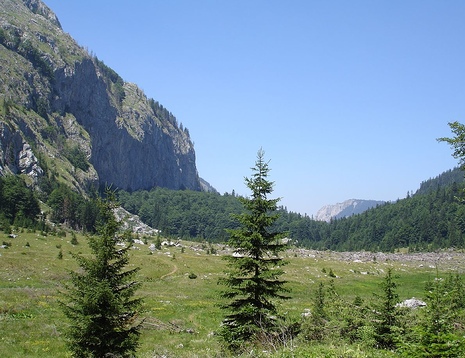
The vegetation of the park consists of dense forests (66%), mountain
pastures, meadows and rocky soil with occasional vegetation. In
particular, on the slopes of the northwestern hills there are thick
conifers and beech trees up to a height of 1,600 meters, while in other
parts the very steep slopes are barren and rocky. Pastures are located
on plateaus above 1,600 meters above sea level. The floral wealth
includes 2,600 species of vascular plants, many of which are rare and
endemic species, as well as approximately a hundred species of edible
mushrooms. The Perućica rainforest consists of large beech trees 60
meters high, with a circumference of about one and a half meters, and
endemic specimens of black pines. The trees in the Perućica rainforest
have never been listed, and some of them are as old as 300 years.
The animal population is diverse and substantial. Bears, chamois,
wild boars, wolves, martens, wild cats, foxes and wild goats have been
seen in the park, especially in the forests of Perućica. In the park,
there are more than 300 species of birds in the area of the large lakes
on Zelengora and in the wetlands. Balkan chamois, a type of
goat-antelope distributed in Europe and the Carpathians, are also among
the species living in the park. In the period from 1963 to 1987, 256
chamois were successfully brought to 13 other areas in Bosnia and
Herzegovina and Croatia. Some of the bird species recorded in the
Perućica rainforest are: golden eagle, grouse, peregrine falcon,
blackbird and partridge.
Conservation and protection
Sutjeska National Park is an associate member of the European Association of National Parks. In view of the overexploitation of natural resources, including illegal cutting of firewood, the World Bank has supported a major multipurpose plan for biodiversity conservation, forest management, cultural heritage preservation, tourism and socioeconomic development. The projects cover the physical enhancement of existing protected areas and the establishment of new conservation priorities for critical areas with funding of US$2.76 million, including US$1.4 million from the Global Environment Facility. The project started in 2006 includes the existing Sutjeska National Park and Kozara National Park with a focus on ecosystem development plans, participatory land use planning, construction of new infrastructure and limited rehabilitation of small-scale buildings, which are considered key to improving the existing park. Infrastructure development includes improvements and new trail alignments, signage repairs, rest areas, and establishment of new park boundaries. An exclusive training program is also part of the project. Since the 1960s, infrastructural development has posed a major challenge to environmental conservation.
Manifestations
The Festival Association of the Republic of Srpska, in cooperation with the National Park, organizes the OK Fest Youth Festival every year at the beginning of July. OK Fest has grown from the Friendship Camp and is attended by young people from the entire Republika Srpska, as well as guests from the region. Conceived as a form of youth and eco-tourism promotion, it offers visitors concerts of famous rock groups, accompanying music programs, film and theater screenings, panel discussions and a very attractive adrenaline zone — hiking in the park and rafting on the Tara River.