Location: Ohrid Map
Constructed: 11th century
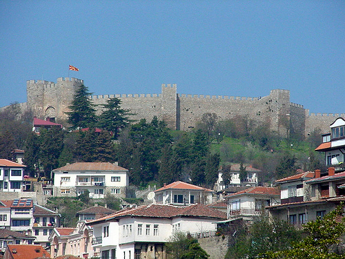
Samuel's Fortress located in a town of Ohrid was an original capital of the First Bulgarian Kingdom during reign of King Samuel. Although the first military fortifications here were constructed in the 4th century BC by Phillip II of Macedon, father of Alexander the Great. Titus Livy called this city Lihnidos in the 3rd century BC and described its walls as mighty and well defended. Apparently it was a major citadel at the time able to withstand major sieges. It became handy as a Roman Empire began to fall apart barbarian tribes flooded into a region. In 479 armies of Goths under leadership of king Theodore tried to capture it and failed despite numerous advantage. Slavs settled here and eventually formed their country that became known as a Bulgarian Kingdom. King Samuel turned into his capital and greatly strengthened military fortifications of citadel's defences in the early 11th century. Most of population of the medieval Ohrid used to live within the walls of the Samuel's Castle. With the arrival of the Ottoman Turkish armies the city grew in size and Ohrid's citizens settled at the base of the hill, leaving medieval walls behind. Today the fortress is open to the public. It is well reconstructed and well maintained, however be careful when you climb walls and towers of the medieval structure.
Ancient Origins (4th Century BC and Earlier)
The
site has deep roots predating the medieval period. Archaeological
evidence indicates an earlier fortification from the 4th century BC,
likely built or significantly developed by King Philip II of Macedon
(father of Alexander the Great).
This aligns with the ancient name of
Ohrid, Lychnidos (or Lychnidus), mentioned in sources like the historian
Polybius. Philip II used it to secure northern borders against Illyrian
tribes and control strategic routes. Excavations have uncovered stone
blocks from this era, placed on internal and outer sides near the
northern ramparts, along with artifacts like amber objects and items
from the 5th–4th centuries BC.
The location was advantageous due to
natural springs within the walls, making it defensible and sustainable.
It played roles in Macedonian-Roman conflicts after Alexander's death
and saw use through various ancient periods.
Medieval Revival
Under Tsar Samuel (Late 10th–Early 11th Century)
The fortress gained
its current fame and name during the reign of Tsar Samuel (also Samuil
or Samoil), ruler of the First Bulgarian Empire (or Western Bulgarian
Empire) from 997 to 1014. Samuel, part of the Cometopuli dynasty,
transformed Ohrid into his capital around 992–1018, moving it from areas
like Prespa or Skopje.
He rebuilt and expanded the existing
structures into a substantial medieval stronghold with massive stone
walls, towers, and ramparts. This made it both a military center and a
symbol of power amid ongoing wars with the Byzantine Empire under
Emperor Basil II ("the Bulgar-Slayer").
Strategic Importance: The
fortress anchored a larger defensive system enclosing much of the old
town, with around 20 wall and gate towers, multiple gates, and walls
extending to the port. Wall heights varied based on terrain (higher and
thicker where vulnerable). It overlooked Lake Ohrid, providing panoramic
surveillance.
Samuel's Empire: Ohrid became the political, cultural,
and ecclesiastical heart of his realm, which at its peak controlled much
of the Balkans. Samuel restored Bulgarian strength after earlier losses,
launching offensives but increasingly defending against Byzantine
advances. The fortress witnessed the empire's resilience and eventual
decline.
Samuel died in 1014 after the catastrophic Battle of
Kleidion. His successors (including son Gavril Radomir and nephew Ivan
Vladislav) held Ohrid briefly until the empire's fall to Byzantium in
1018.
Post-Samuel History (11th–19th Centuries)
The fortress
changed hands multiple times:
Byzantine Period: After 1018, it served
Byzantine interests. Emperor Alexios I Komnenos likely restored parts of
it.
Later Medieval and Ottoman Eras: It was damaged, rebuilt, and
upgraded under various rulers, including during the 14th century under
local figures like Andrea Gropa. It bears traces from Roman, Byzantine,
Slavic, and Ottoman periods.
Ohrid remained significant, but the
fortress gradually declined over centuries of conflict and neglect.
Modern Era: Excavations and Restoration
Systematic archaeological
work in recent decades, particularly under Macedonian archaeologists
like Pasko Kuzman, has clarified its layers. Excavations in the early
2000s revealed ancient foundations and confirmed Philip II's
involvement.
Major restoration occurred around 2000–2003, involving
conservation, repair of walls and towers, and addition of new
battlements (where original ones had not survived). This preserved the
central citadel while making it accessible. Today, it is part of the
UNESCO World Heritage Site encompassing Ohrid and Lake Ohrid (cultural
and natural heritage).
The fortress has deep roots. Archaeological evidence and historical
sources indicate fortifications on the site dating back to the 4th
century BCE, likely established or expanded by King Philip II of
Macedon. Ancient sources like Polybius mention early defenses for the
city of Lychnidos (ancient Ohrid).
Later Roman, Byzantine, and other
rulers used and modified the site due to its strategic overlook of the
lake and surrounding lands. The current prominent form largely dates to
the late 10th–early 11th century under Tsar Samuel, who expanded earlier
structures into a formidable medieval stronghold after making Ohrid his
capital around 992–1018.
The fortress endured multiple destructions
and rebuilds across eras (Byzantine, Slavic, Ottoman), incorporating
spolia (reused ancient stones, some with Greek inscriptions).
Overall Layout and Scale
The fortress complex, including the citadel
and associated city walls, encloses much of the Ohrid hill. The
defensive system extends roughly 3 kilometers in total length,
protecting the city on all sides except the southern lake-facing slope
(which relied on natural defenses and the port area).
Citadel:
The upper fortress on the highest point, containing ruins of the royal
palace, barracks, and inner defenses.
City Walls: Lower ramparts
connecting to the broader urban area.
It integrates the natural
topography of the hill for defense, with varying wall heights adapted to
terrain accessibility.
The complex originally featured around 20
wall and gate towers plus multiple gates. Today, visitors see remains of
18 towers and 4 gates.
Materials and Construction Techniques
Primary Material: Local limestone, often in large, irregular blocks for
durability.
Byzantine Influence: Visible in some sections with
horizontal layers of bricks (typical Byzantine opus mixtum technique)
beneath outer layers.
Thickness and Height: Walls range from about 6
to 16 meters high (some sources note up to 18 meters in places) and
several meters thick, designed for strength against sieges.
Construction includes recycled ancient stones, reflecting pragmatic
reuse across centuries.
The design reflects medieval Balkan
military architecture with Byzantine and regional Slavic elements,
emphasizing height, thickness, and integration with terrain.
Key
Architectural Features
1. Defensive Walls and Ramparts:
Massive
stone curtain walls with crenellations (battlements). Many sections have
been heavily restored (notably in 2003, adding new battlements),
allowing visitors to walk along extensive stretches.
Walls adapt to
the hill's contours, creating a multi-layered defense.
2. Towers:
A mix of shapes, including rectangular and semicircular/round towers.
Towers project from the walls for flanking fire and surveillance. The
largest and strongest tower guards the weakest point of the fortress.
Many retain their solid, imposing character, with some featuring
internal stairs or platforms.
3. Gates:
Four main gates
remain. The primary entrance to the citadel is particularly impressive,
flanked by two semicircular defensive towers, creating a strong,
monumental gateway.
Gates were critical choke points, often
reinforced with additional defenses.
4. Interior and Palace Area:
The inner citadel includes ruins of the royal palace and barracks.
Today, the interior is relatively open with grassy areas, archaeological
remnants, and foundations rather than intact buildings—emphasizing the
defensive shell over luxurious interiors.
Limited surviving internal
structures reflect centuries of decay and reuse.
5. Additional
Elements:
Springs within the walls ensured water supply during
sieges.
Strategic placement provided panoramic surveillance over the
lake, town, and approaches.
Modern Restoration and Visitor
Experience
In 2003, significant restoration work added new
battlements and improved access, making it a major tourist site.
Visitors can climb walls and towers for stunning views of Ohrid's old
town (with its red roofs), Lake Ohrid, and surrounding mountains
(including Galicica National Park).
The site is part of the UNESCO
World Heritage listing for the Ohrid region (cultural and natural).
While the interior feels somewhat sparse (ruins and open space), the
scale of the walls and views make it impressive.