Location: Librajd County
Area: 33,928 hectares
Shebenik-Jabllanicë National Park, often referred to as Shebenik
National Park, is a vast protected area in eastern Albania,
bordering North Macedonia. Spanning 34,507.9 hectares (approximately
345 square kilometers), it encompasses rugged mountain landscapes,
ancient forests, glacial lakes, and diverse ecosystems. Established
to preserve one of the Balkans' most pristine wilderness areas, the
park lies primarily in the Librazhd District of Elbasan County, with
extensions into neighboring regions. It serves as a critical habitat
for endangered species like the Balkan lynx and forms part of the
European Green Belt initiative, promoting cross-border conservation.
The park's name derives from its two dominant massifs: Mount
Shebenik (2,253 meters) and Mount Jabllanicë (2,257 meters),
offering a haven for outdoor enthusiasts and nature lovers seeking
untouched Albanian wilderness.
Best Time to Visit
Optimal periods: Late May to early October.
Trails are most accessible, and wildlife is active.
Late May–June:
Spring blooms, milder temperatures (15–20°C daytime), fewer crowds.
July–August: Warmest (up to 30°C lower down), vibrant wildflower
meadows, but hotter on exposed ridges and busier with locals on
weekends.
September–early October: Stunning autumn foliage in beech
forests, stable weather, cooler hikes.
Avoid: Winter (snow blocks
high trails until May) and late autumn (heavy rains). Higher elevations
can have snow into late spring.
Weather changes quickly at altitude —
always check forecasts.
How to Get There
The park lies
southeast of Elbasan, near towns like Librazhd and Prrenjas.
From
Tirana (most common starting point): ~2–3 hours by car. Drive via
Tirana–Elbasan–Librazhd or Prrenjas. Public buses/minibuses go to
Librazhd or Prrenjas; from there, take a taxi, minibus, or hitch to
trailheads/villages like Rrajc, Fushë Studë, or Dorez.
By train:
Limited service on the Tirana–Pogradec line stops in Librazhd/Prrenjas.
By car/4x4: Recommended for flexibility. Many access roads are
unpaved/dirt; 4x4 is ideal for rougher tracks. Rent in Tirana if needed.
Organized tours: 2-day hikes from Tirana (including mountain hut stays)
are available via platforms like GetYourGuide. Local guides enhance
wildlife spotting and navigation.
Trailheads often require a short
taxi/hitch from nearby villages.
Entrance Fees and Permits
No
formal entrance fees (free access, open 24/7).
Informal or small fees
(€2–5) may apply at some spots or for camping in designated areas
(€5–10/night).
No permits generally needed for hiking, but check with
the visitor center for multi-day trips or border areas.
Things to
Do and Top Trails
Hiking is the main activity. Trails range from easy
meadow walks to challenging summit/ridge routes. There are about 4
marked trails, plus many shepherd paths.
Highlights:
Maja e
Shebenikut (Shebenik Summit, 2,253 m): Strenuous 8–10 hour climb (or
2-day with camping). Panoramic views into North Macedonia.
Glacial
Lakes Circuit (e.g., Rrajca Lakes/Liqenet e Rrajcës): Moderate 4–6
hours, connecting pristine lakes for swimming, photography, and picnics.
Jabllanica Ridge: Long exposed ridge walks with wildflowers and dramatic
drops — ideal for multi-day treks.
Ancient Beech Forests (Rrajca):
Serene, primeval woodland hikes (UNESCO site).
Other: Swim in
rivers/lakes, wildlife viewing (dawn/dusk), mountain biking on some
trails, village festivals in early summer.
Difficulty: Moderate to
strenuous overall. Good fitness required for high routes; navigation can
be tricky off main paths.
Accommodations and Camping
Inside/near park: Limited. Basic guesthouses in villages like Dardhë or
Fushë Studë (rustic, home-cooked meals). Mountain huts for multi-day
hikes.
Nearby towns: Prrenjas, Librazhd (budget hotels/hostels), or
farther in Korçë/Elbasan for more options.
Camping: Allowed (wild
camping common). No official sites — practice Leave No Trace. Check
you're not on private land. Bring a sturdy tent; nights get cold at
altitude.
What to Bring and Practical Tips
Essentials: Sturdy
hiking boots, layers (temperatures drop at night/elevation), rain
jacket, hat/sunscreen, headlamp, first aid kit, water
filter/purification, GPS/offline maps (e.g., Outdooractive, Gaia GPS, or
local maps from visitor center), power bank, cash (limited cards/ATMs).
Food: Limited options inside — bring snacks/packed lunches. Buy fresh
cheese, buttermilk, or raki from villagers. Wild berries in season.
Safety:
Wildlife: Bears and wolves present — store food properly,
make noise on trails, avoid dawn/dusk if solo. Rare attacks, but respect
distance.
Terrain/Weather: Steep/rocky sections, river crossings,
quick weather changes. Tell someone your plans.
Health: Hydrate, pace
yourself. No major medical facilities nearby.
Border: Some areas near
North Macedonia — stay on Albanian side.
Visitor Center: In Fushë
Studë — good for maps, info, ranger contacts (e.g., Rejland Hasa or
Elton Brazhda). Open longer in summer.
Additional Advice
Crowds: Very low compared to coastal or Alps spots — great for solitude.
Sustainability: Stick to trails, pack out trash, support local
communities.
Combine with: Nearby Pogradec/Lake Ohrid, or other parks
like Lurë-Dejë for a longer trip.
Budget: Very affordable — low
entry/transport costs, cheap local food/accommodation.
Location and General Setting
The park lies in the
Elbasan County (primarily Librazhd and Bulqizë regions), north of Lake
Ohrid, in the Dinaric Alps system. It occupies a strategic position in
the Southern European Green Belt, serving as an ecological corridor.
Nearest towns include Librazhd and Prrenjas. Coordinates center around
41°10′N 20°30′E. The terrain is remote and relatively undeveloped,
blending with villages and traditional land use on the periphery.
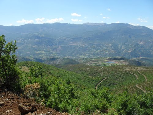
Topography and Mountain Ranges
The park is defined by two
connected mountain massifs: Shebenik and Jabllanice (Jablanica), which
give it its name. Elevations range dramatically from about 300 m in
valley floors to over 2,200 m at the summits.
Highest peak: Maja e
Shebenikut (Shebenik Peak) at 2,265 m (prominence ~1,336 m).
Other
notable peaks include Black Stone (Crn Kamen, 2,257 m), Čumin Vrv (2,125
m), Raduč (2,083 m), and several others above 2,000 m. There are around
28 named mountains.
The landscape features steep ridges, deep
U-shaped valleys (carved by glaciers), cirques, high-altitude plateaus,
and alpine meadows. Foothills transition into dramatic rocky peaks, with
pastures and forests on the slopes. Glacial activity during the last Ice
Age shaped much of the current rugged scenery, including cirque
depressions and moraines.
Geology
The geology is complex and
diverse, reflecting a long history:
Rocks date from the Triassic and
Jurassic periods (Mesozoic), with evidence of deposition and the
Variscan orogeny.
Predominant formations include ultramafic and
metamorphic rocks, but calcareous (limestone) rocks are very common,
especially in southern and southeastern sections.
Significant karst
features dominate higher areas: caves (e.g., Kosharishti cave, Ice
Cave/Shpella e Akullit), karst springs, sinkholes, and underground
drainage systems. The bedrock above the forest belt is largely
carbon/karst-based.
Post-glacial sediments have contributed to
fertile soils in valleys.
This mix of silicate, limestone, and karst
creates varied microhabitats and dramatic landforms.
Hydrology
Water is a defining feature:
14 glacial lakes (cirque lakes), mostly
at 1,500–1,900 m elevation. Notable ones include Lake Shebenik, Lake
Rrajca, Fushë Studnë, and Dragostunja. These are clear, often
small-to-medium, and fed by snowmelt/rain.
Major rivers: Qarrishte
and Bushtrice (both ~22 km long within the park), plus numerous streams
and tributaries. These flow through valleys and eventually contribute to
the Adriatic drainage.
Abundant springs, karst water sources, and
smaller watercourses. The rugged terrain creates waterfalls and
fast-flowing sections.
Hydrology supports rich ecosystems and adds to
the scenic beauty.
Climate
The park has a moderately warm,
rainy continental climate with strong Mediterranean influences, varying
significantly by altitude (orographic effect).
Lower elevations:
Milder, with warmer summers.
Higher elevations: Cooler temperatures,
longer snow cover (often until May on peaks).
Annual precipitation:
1,300–1,800 mm, higher on windward slopes.
Seasons: Dry, warm
summers; cool, wet winters. Snow is common in winter at higher
altitudes.
This altitudinal gradient drives biodiversity by creating
distinct vegetation zones.
Vegetation and Ecosystems
Diverse
topography, geology, climate, and hydrology produce contrasting
ecosystems:
Forests: Dense coniferous (fir, pine, spruce), deciduous
(beech, oak), and mixed stands. Ancient/virgin beech forests in Rrajcë
are part of a UNESCO World Heritage Site (Ancient and Primeval Beech
Forests).
Alpine meadows and pastures: Above the tree line.
Shrublands and grasslands: Especially at higher elevations.
The park
hosts about 32% of Albania’s flora, including many endemics and rarities
(e.g., Albanian rock rose, Albanian pansy).
Vegetation shifts from
lowland/montane forests to subalpine and alpine zones.
Overall
Geographic Character
Shebenik-Jabllanice stands out for its vertical
diversity within a compact area: deep valleys with rivers and villages
transition rapidly to forested slopes, rocky peaks, glacial lakes, and
alpine tundra-like zones. Glacial and karst processes have created a
mosaic of habitats that support high biodiversity, including large
mammals like brown bear, gray wolf, and the rare Balkan lynx. Its border
location and remoteness preserve a sense of wilderness, though
traditional shepherding and villages persist on the edges.
Geological and Prehistoric Foundations
The park’s
deep history begins millions of years ago. Its mountains (Shebenik and
Jabllanice massifs) formed during the Variscan orogeny, composed mainly
of ultramafic and metamorphic rocks, with significant calcareous and
karst formations, especially in southern and southeastern areas.
Sedimentary records span the Middle Triassic to Jurassic periods.
During the last Ice Age, massive glaciers sculpted the landscape,
creating U-shaped valleys, cirques, and the park’s iconic 14 glacial
lakes (many between 1,500–1,900 m elevation). Post-glacial sediments
enriched the soil, supporting high fertility in valleys and meadows.
This glacial legacy defines the park’s dramatic terrain, with elevations
ranging from ~300 m in valleys to 2,253 m at the summit of Mount
Shebenik.
Human Presence and Cultural History
Human activity
in the region dates back centuries, though the rugged, remote border
location limited large-scale development.
Historical and Cultural
Sites: The park includes sites linked to Skanderbeg (Gjergj Kastrioti),
Albania’s national hero who resisted the Ottoman Empire in the 15th
century. Notable features include Scanderbeg’s Staircase and
Scanderbeg’s Table. There are also natural caves like “Glacier Cave”
(Shpella e Akullit), “Christ’s Cave,” and the “Eremite Cave,” some
containing wall paintings.
Traditional villages such as Qukesi
preserve old ways of life. Local communities maintain skills in wood
carving, stonework (e.g., millstones), stone-house construction,
traditional costumes, and folk dances. The Ethnographic Museum in nearby
Librazhd holds cultural artifacts, though it has faced damage.
The
area’s isolation as a sensitive border zone (especially during the
communist era) helped preserve its natural state, with limited
infrastructure and human impact compared to more accessible Albanian
regions.
Folklore includes tales like the “Shebenik Treasure,” a
legendary fortune supposedly buried during Ottoman times.
Establishment as a National Park (2008)
The park was created on 21
May 2008 as part of Albania’s post-communist efforts to expand its
protected areas network and promote biodiversity conservation. It
followed the earlier establishment of Prespa National Park (1999). The
creation recognized the area’s exceptional biodiversity, old-growth
forests, and role as a habitat for endangered species.
It is managed
by a directorate under the National Agency of Protected Areas (part of
the Ministry of Environment), based in Librazhd and Prrenjas. In January
2022, the park was slightly expanded from 33,894 ha to its current size.
International Recognition and Conservation Milestones
UNESCO
World Heritage: The ancient beech forests of Rrajcë (Rrajca) form part
of the transnational “Ancient and Primeval Beech Forests of the
Carpathians and Other Regions of Europe” UNESCO site. These represent
some of Europe’s last primeval forests.
European Green Belt: The park
lies within this ecological corridor along the former Iron Curtain,
serving as a refuge for wildlife.
IUCN Category II: It holds formal
protected status emphasizing ecosystem protection and recreation.
Important Plant Area: Recognized by Plantlife for the Shebenik,
Jabllanice, and Rrajcë regions.
Conservation focuses on flagship
species like the critically endangered Balkan lynx (one of Albania’s
last populations), brown bear, gray wolf, and various birds (e.g.,
golden eagle). The park supports diverse habitats: coniferous/deciduous
forests, alpine meadows, and rivers like the Bushtrica and Qarrishte.
Post-Establishment Development
Since 2008, the park has seen
gradual development for ecotourism, with marked trails, information
points, and community involvement. Annual celebrations on 21 May
(establishment anniversary) in Fushë Studë include fairs, traditional
food, music, dances, and Junior Rangers programs.
Challenges include
balancing local agriculture/livestock (sheep, goats, some crops) with
conservation, and promoting sustainable tourism in a still relatively
underdeveloped area. The park remains one of Albania’s wildest, with a
mix of pristine wilderness and lived-in valleys featuring shepherd
paths.
Shebenik-Jabllanicë boasts exceptional biodiversity,
harboring 32% of Albania's total flora within its boundaries, making it
a hotspot for endemic and rare species.
Flora
The park's
vegetation is zoned by altitude: Lower slopes feature Mediterranean oaks
(Quercus ilex) and hornbeams, transitioning to mixed deciduous forests
of European beech (Fagus sylvatica) and black pine (Pinus nigra). Higher
elevations host Balkan endemic species like Macedonian pine (Pinus
peuce) and Bosnian pine (Pinus heldreichii), alongside alpine meadows
rich in edelweiss, gentians, and orchids. Ancient beech stands, some
over 500 years old, form dense canopies that support unique
microhabitats. Rare plants include the Albanian lily (Lilium albanicum)
and various ferns adapted to serpentine soils.
Fauna
Wildlife
thrives due to the park's isolation and varied habitats. Large mammals
include the brown bear (Ursus arctos), gray wolf (Canis lupus), and the
critically endangered Balkan lynx (Lynx lynx balcanicus), with fewer
than 50 individuals estimated in the wild. Other notable species are the
chamois (Rupicapra rupicapra), wildcat (Felis silvestris), Eurasian
otter (Lutra lutra), and roe deer (Capreolus capreolus). Birdlife is
abundant, with over 140 species recorded, including golden eagles
(Aquila chrysaetos), peregrine falcons (Falco peregrinus), and black
woodpeckers (Dryocopus martius). Reptiles and amphibians, such as the
Albanian water frog (Pelophylax shqipericus), add to the diversity,
while invertebrates like rare butterflies flourish in the meadows.
The park offers a range of attractions for visitors:
Hiking
and Trekking: Well-marked trails lead to summits like Mount Shebenik,
glacial lakes, and viewpoints. Popular routes include the Qarrishtë
Valley trail (moderate, 10 km) and the ascent to Liqeni i Madh
(challenging, offering panoramic views).
Glacial Lakes and
Waterfalls: Explore serene lakes formed by Pleistocene glaciers, ideal
for picnics and photography.
Villages and Cultural Sites: Traditional
settlements like Steblevë provide insights into rural Albanian life,
with guesthouses offering local cuisine such as grilled meats and byrek.
Wildlife Watching: Guided tours for spotting lynx or bears, best in
spring or autumn.
Adventure Sports: Opportunities for mountain
biking, rock climbing, and winter snowshoeing.
Access is via
Librazhd (1-2 hours from Tirana) or Pogradec, with 4x4 vehicles
recommended for remote areas. Entry is free, but permits may be needed
for certain zones.